Howdy, folks! In my most recent article for SCG, I wrote about
how I enjoyed the “real-world” basic lands of the Euro and APAC series and imagined how a similar set themed around North America might look. I
had lots of fun researching and picking out various spots for the article, and from the comments I received, a lot of readers enjoyed it too, so thank you.
I also got some questions about why I’d stuck with the USA and Canada when “North America” also includes (in many but not all senses) nations such as Mexico, Panama, Cuba, and so on. I used “North
America” the way Wizards of the Coast defines it for corporate purposes, as in Appendix A of the Magic Premier Event Invitation Policy. This leads to some
interesting quirks, as the Wizards definition doesn’t just include the USA and Canada, but also select US territories (American Samoa, Puerto Rico, the US
Virgin Island) plus Bermuda* and the Middle Eastern countries Bahrain and Iraq**.
* Wizards doesn’t list any places to buy Magic cards in Bermuda, which is
technically a British Overseas Territory
but is located closer to North America than Europe. Wizards isn’t particularly consistent on this point, however, as the US Virgin Islands are
considered North America but the British Virgin Islands are considered Europe! It’s basically a moot point, as
the nearest Wizards Play Network stores to the Virgin Islands are in Puerto Rico and the Dominican Republic
, but one never knows where the next great Magic Online player might emerge… or move to…
** Bahrain and Iraq presumably are listed under North America due to US military influence. Iraq is
fairly obvious
, while
Bahrain
, a small island kingdom, is home to
a major US Navy base
.
I mentioned Puerto Rico up above, and that’s the one spot I feel kind of bad about, because I’d thought Puerto Rico would be part of Latin America by the
Wizards definition, not North America, and I failed to do the research. Whomp whomp. To make it up to Puerto Rico, here’s a bonus listing for it.
Island –
Vieques
, Puerto Rico.
The island of Vieques, located off the east coast of the island of Puerto Rico, has a long and tumultuous history that mostly amounts to getting screwed
whenever Europeans or Americans showed up. Early in the 1500s the Spaniards wrecked the local population, and over the next 300 years other powers,
including Scotland and Denmark, tried to claim the island without much success. The 19th century was the time of sugar plantations, but the
Spanish-American War of 1898 brought Vieques and the rest of Puerto Rico under US control. Vieques controversially was used as a weapons testing and military training area from 1941 to
2001. Since then, much of Vieques has become a National Wildlife Refuge,
protecting coral reefs, mangrove forests, and other habitats in the area.
…well, that was a detour and a half! Getting back to “North America” and “Latin America,” based on feedback from readers like you, folks wanted to see
the Latin American version of the basic land set, so here it is! A half-dozen notes:
1) I chose three versions of each basic land (Plains, Island, Swamp, Mountain, Forest) for a total of fifteen locations.
2) No country is represented more than once in the credit. Because many of the environments are transnational, sometimes I credit one country for
a place that crosses borders. This affects broader ecosystems (Plains, Swamp, Forest) moreso than single, smaller locations (Island, Mountain).
3) All countries represented sent a team to the World Magic Cup in 2015.
4) Because of rules 1-3 above, some iconic sites just didn’t make it into this list. Let’s face it, there are way more than three famous mountains in Latin
America, and choosing just one place for all of Brazil was the hardest part of making the list. Among the locations that didn’t make the cut for Brazil:
the Amazon Rainforest, Sugarloaf Mountain, and Corcovado with
the iconic Christ the Redeemer statue atop it.
5) Accents and the article upload process don’t play nicely, so I’ve omitted them. Yes, there should be accent every time “Rio” appears.
6) I would’ve written this two weeks ago, but I was on vacation in Hawaii. Sorry not sorry.
The Latin America Land Set
Plains
Plains #1 –
Pampas
, Uruguay.
The Pampas stretch from Argentina to Brazil, with Uruguay, the small coastal country between them, almost entirely dominated by the Uruguayan savanna subregion of the Pampas. Historical uses of the Pampas put the “culture” in
“agriculture,” particularly the famous cattle ranches tended by gauchos and celebrated in Latin
American writing, most notably the Argentine poem Martin Fierro.
Plains #2 –
Los Llanos
, Venezuela.
Split almost evenly between Venezuela and Colombia, Los Llanos (“the plains”) are another famous cattle ranching area, located east of the Andes Mountains
and just above the Equator. A place of many rivers, Los Llanos varies from relatively dry to almost swampy depending on the season and the rains.
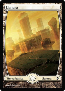
Magic uses a slightly different term for its “Plains.”
Plains #3 –
Altiplano
, Bolivia.
Unlike the fertile environs of the Pampas and Los Llanos, the Altiplano of western South America is a largely dry place dominated by salt flats and other
stretches of high-elevation (averaging well over 10,000 feet), low-variability terrain. Among the most famous places within the Altiplano areLake Titicaca, the Bolivian de facto capital of La Paz, and the “mountain of silver,” Cerro Rico,
that was the source of much Spanish wealth during the area’s colonial period.
Island
Island #1 –
Galapagos Islands
, Ecuador.
This small island chain off the western coast of Ecuador had its “moment” when Charles Darwin
used his observations of the unique life forms there to support his iconic book about evolution, On the Origins of Species. Today the Equator-straddling Galapagos
Islands remain a (pricy!) draw for tourists, though balancing the competing interests of would-be wildlife watchers and the needs of the fragile Galapagos
ecosystem is an ongoing struggle.
Island #2 –
Rapa Nui / Easter Island
, Chile.
The easternmost “corner” of the Polynesian Triangle, Easter Island (“Rapa Nui” in the
aboriginal language) is one of the most isolated islands on earth, which makes its discovery and settlement by Polynesian navigators all the more remarkable. Easter Island is most famous for the giant
stone statues, or moai, carved by the Rapa Nui people while the early civilization still thrived. The moai
remain a source of fascination for modern tourists and are protected as part of a UNESCO World Heritage Site.

A moai, some land, blue water, blue sky: the perfect (Easter) Island. Image source: Wikipedia
Island #3 –
Ometepe / Lake Nicaragua
, Nicaragua.
Going into Central America for the first time in this list, Ometepe is not an ocean island but contained within a lake, Lake Nicaragua. Formed by two
volcanoes, Ometepe and its surrounding lake have seen a long human history, including pirate attacks and multiple schemes to build a canal connecting the
Atlantic and Pacific Oceans.
Swamp
Swamp #1 –
Pantanal
, Brazil.
Literally the largest swamp (wetland, technically) area on Earth, the Pantanal is on the southwestern border of Brazil with extensions into neighboring
Bolivia and Paraguay. Among the many plant and animal species found within the Pantanal, its jaguar population is noted for its robustness — and the large size of its individuals.

A Swamp in (Brazilian) Portuguese. Note the similarity between names.
Swamp #2 –
Parana Delta
, Argentina.
Where the Parana River splits and meets the Rio de la Plata, a sizable and historically
important area of islands and wetlands may be found just upriver of Buenos Aires. The Parana Delta is a rich source of fish among other sea resources.
Protected areas of the Parana Delta include a small Argentine national park, Predelta,
and the larger Parana Delta Biosphere Reserve.
Swamp #3 –
Atrato River delta
, Colombia.
This swampy delta near Colombia’s border with Panama (the history is complicated) is the meeting-place of the Atrato River and the Gulf of Darien, the southernmost part of the Caribbean Sea. The vast marshland is noted in North
American travelers’ circles as part of the so-called “Darien Gap,” a break in the Pan-American
Highway.
Mountain
Mountain #1 –
Machu Picchu
, Peru.
The nation’s most famous historical landmark and tourism site, Machu Picchu lies high in the Andes Mountains. One of the few Inca sites not totally wrecked
by the Spanish conquistadores, Machu Picchu was unknown to the Western world until the early 1900s, when Hiram Bingham III asked around and got led there. UNESCO recognized Machu Picchu as a World
Heritage Site in 1983.
Mountain #2 –
Pico Duarte
, Dominican Republic.
The mountainous Caribbean island of Hispaniola is divided between French-speaking Haiti to the west
and the Spanish-speaking Dominican Republic to the east. The tallest mountain on Hispaniola (and on any Caribbean island), Pico Duarte is one of the few
places in the Caribbean where the temperature goes below freezing naturally. Forget palm trees; think pine trees!

Pico Duarte. Image source: Wikipedia
Mountain #3 –
Popocatepetl
, Mexico.
Though not the tallest peak in Mexico, this active volcano certainly is the most famous, thanks in part to its proximity to Mexico City. Once
glacier-capped, now merely ice-crowned, Popocatepetl is associated with a mythic warrior in the area’s lore. The area around
the volcano was one of the early focuses of Roman Catholicism in Mexico, and fourteen monasteries in the area are gathered under a UNESCO
World Heritage Site.
Forest
Forest #1 –
Corcovado National Park
, Costa Rica.
Costa Rica’s tourism economy is closely linked to its rainforests, and few locations are as accessible and beautiful as Corcovado in the southwest of the
country. While many surviving tropical rainforests are in hard-to-access (and thus hard-to-exploit) hilly areas, Corcovado protects a lowland tropical
rainforest on Costa Rica’s Pacific coast.
Forest #2 –
Tikal
, Guatemala.
An important archeological site for study of the Maya during their height, Tikal was home to
tens of thousands of people and one of the largest Western Hemisphere cities of its time. Later it was abandoned for hundreds of years with jungle growing
around the stone architecture, particularly the famous pyramid-shaped temples. Today the area is valued both for its natural and cultural properties, and
it was one of the earliest locations recognized by UNESCO as a World Heritage Site.
Like this, but in real life and minus the Egyptian-themed dude.
Forest #3 –
Cerro Cora National Park
, Paraguay.
Another location with both natural and historical value, Cerro Cora has forests ranging from small savannah-like trees to rainforests. Ancient rock
carvings, or petroglyphs, are the first recorded testimonies left by humans in Cerro Cora. More recently, in 1870, Cerro Cora was the site of the last battle in the Paraguayan War, one of the most violent and drawn-out
international conflicts on the continent.
***
I hope you’ve enjoyed this look at what a set of Latin American basic lands might look like! Don’t forget to share your views (and your picks!) in the
comments.
May the New Year bring you health and happiness!